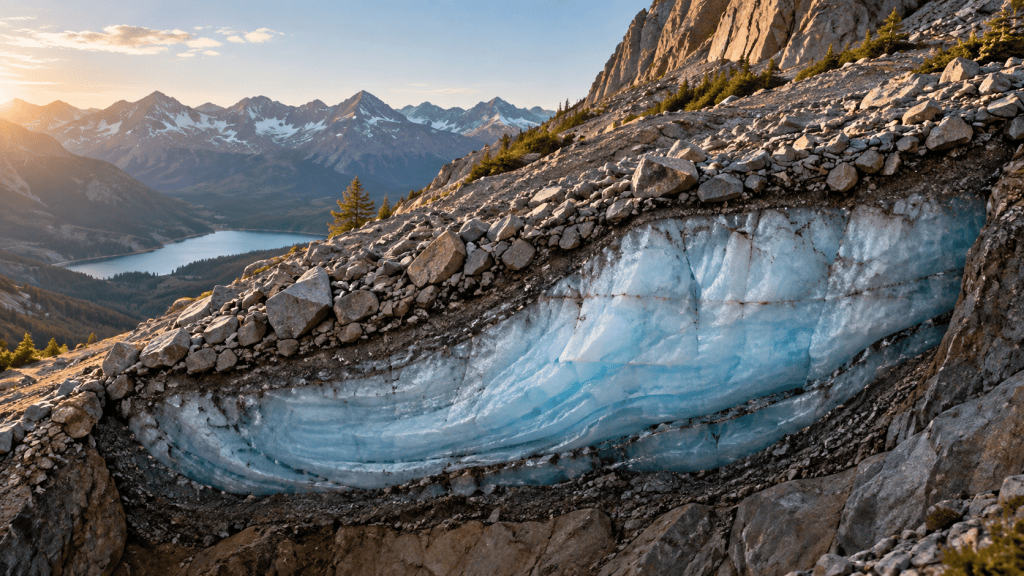
A glacier is supposed to look like ice. It gleams white or blue,
carries crevasses and announces itself as frozen water. A rock glacier
can resemble a heap of rubble.
In Utah’s mountains, researchers used gravity measurements to
investigate one such landform below Mount Timpanogos. Their results
suggested that about 83 per cent of its volume was ice—around 1.5
million cubic metres, often compared with roughly 600 Olympic swimming
pools.
The finding makes sense once a glacier is understood not by colour
but by behaviour.
Ice and debris move together
Rock glaciers are masses of broken rock containing ice within pores,
layers or a more substantial frozen core. Under gravity, the ice-rich
mixture deforms and creeps downhill, usually far more slowly than a
clean, active glacier.
Their surfaces can form ridges and furrows as the material moves.
Large boulders insulate the ice below from direct sunlight, allowing it
to persist where exposed ice might melt faster.
Not every rocky slope is a rock glacier. Shape, movement, temperature
and internal structure help distinguish one from an ordinary landslide
deposit or moraine.
How can scientists
see through the stones?
Drilling gives direct evidence but samples only particular points and
can be difficult in unstable terrain. Researchers combine techniques
instead.
Repeated satellite or ground surveys can detect slow surface
movement. Electrical and seismic methods reveal contrasts between frozen
and unfrozen material. Temperature measurements indicate permafrost
conditions.
Gravity offers another clue. Every material exerts gravitational
attraction, but rock is denser than ice. By measuring tiny changes in
the local gravitational field across the landform and modelling its
shape, scientists can estimate how much low-density ice must lie within
it.
The calculation is not a photograph. It depends on assumptions about
rock density, geometry and subsurface mixtures, so results carry
uncertainty. Multiple methods make the interpretation stronger.
Hidden ice matters in dry
country
Mountain snow and ice store winter precipitation and release water
later. A debris-covered body can respond more slowly than exposed snow,
potentially sustaining cold-water flow during dry periods.
That does not make every rock glacier a large dependable reservoir.
Water may refreeze, drain underground or emerge gradually. Climate,
internal structure and local hydrology determine its contribution.
In Utah, researchers have catalogued hundreds of rock glaciers.
Scaling observations across all of them suggests they may collectively
hold around a billion tonnes of ice, but that statewide figure is an
estimate rather than a measured total.
Insulation
delays change; it does not prevent it
The rock cover protects buried ice from short-term heat, which is why
these landforms can survive in places where clean glaciers are absent.
Yet warmer conditions can deepen seasonal thaw and change movement or
drainage. Loss may be slow and difficult to observe until the structure
begins to slump.
This makes mapping valuable. Water managers cannot account for a
store they do not know exists, and hazard planners need to understand
when ice-cemented slopes may become less stable.
A glacier defined by its
interior
Rock glaciers challenge the visual categories used in everyday
geography. Surface appearance says “mountain debris”; internal
composition and motion say “frozen body”.
They are reminders that landscapes hide processes. A valley wall may
move millimetres, groundwater may travel without a stream, and a field
of sun-warmed boulders may shelter ancient ice.
The glacier has not disappeared. It has put on armour.
Quick facts
- Rock glaciers are mixtures of rock debris and ice that creep
downhill. - A surface layer of boulders can insulate buried ice.
- Gravity measurements exploit the density difference between rock and
ice. - Researchers estimated the Timpanogos rock glacier contains about 1.5
million cubic metres of ice. - Utah’s statewide total is a modelled estimate and remains
uncertain.




Leave a Reply