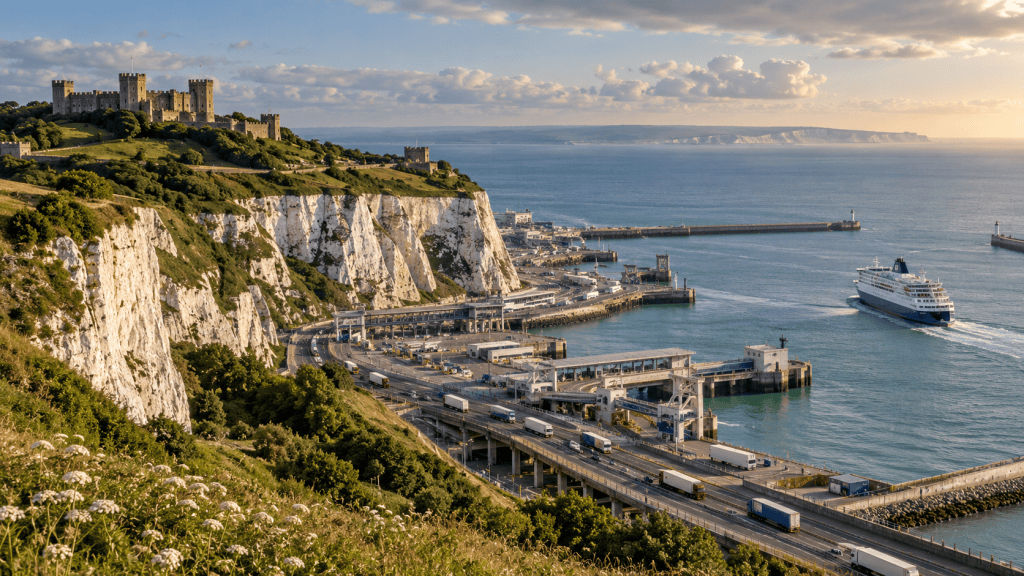
Dover appears whenever Britain’s connection with continental Europe
becomes visible. Holiday traffic queues there. Freight disruption
accumulates there. Armies feared invasion there, while travellers looked
for the first white cliffs on the return home.
The town’s importance can seem political, but it begins with physical
geography. South-east England and northern France approach one another
across the narrowest part of the English Channel. Once people decide to
cross, Dover is difficult to ignore.
The shortest water
is not the whole journey
The Strait of Dover narrows the sea crossing to roughly 34 kilometres
at its closest points. A short crossing saves time and limits exposure
to difficult weather. The chalk cliffs provide an unmistakable landmark
from the water.
A port, however, succeeds only if travellers can reach it from both
sides. Routes across Kent connected Dover to London; routes from Calais
led into northern France and beyond. Roman roads, turnpikes, railways
and motorways successively reinforced the same corridor.
Each improvement made the location more useful, encouraging the next.
Geography offered an advantage; infrastructure compounded it.
Gateway
and fortress are the same idea viewed differently
The easiest place to arrive can also be the place most urgently
defended. Dover Castle occupies high ground above the harbour, with
layers ranging from a Roman lighthouse and medieval fortification to
tunnels used in later wars.
The castle did not protect an abstract coastline. It watched a route
through which people, messages and armies could move. During the
Napoleonic period, further defences and tunnels responded to invasion
fears. In the Second World War, Dover’s position again made it
operationally vital and dangerously exposed.
The phrase “front door” therefore has two meanings. It welcomes
wanted movement and concentrates anxiety about unwanted movement.
The modern port is
part of a moving road
Ferries appear to cross open water, but modern roll-on/roll-off
operations behave like a section of motorway. Lorries drive aboard,
cross and drive away. The vessel, berth, check-in lanes, border controls
and roads form one system.
The Port of Dover recorded more than nine million passengers and over
two million road-haulage vehicles in 2025. Volumes of that scale explain
why a delay can quickly leave the harbour. There is limited room between
sea and cliffs, while vehicles continue arriving from the M20 and
A2.
Traffic-management schemes farther into Kent are evidence of Dover’s
geography reaching inland. A blocked berth can become a motorway
problem; a border procedure can become a queue across a county.
Why not spread
traffic evenly around Britain?
Other ports connect Britain to Europe and can offer more space or
different destinations. The Channel Tunnel also carries passenger and
freight vehicles nearby. Yet networks are shaped by accumulated
investment. Hauliers choose crossings around sailing frequency, road
connections, destination and reliability, not only distance.
Dover’s frequent short crossings are difficult to reproduce at a port
requiring a much longer sea journey. Moving traffic elsewhere may reduce
pressure in one place while increasing sailing time, cost and
emissions.
A national symbol built
from movement
The White Cliffs became an emotional emblem partly because they mark
arrival and departure. Their meaning comes from being seen at a
threshold. The same geology that created the dramatic landscape helped
identify a practical route.
Dover’s recurring prominence is not a failure to invent alternatives.
It is what happens when topography, roads, markets and history keep
voting for the same narrow point.
Britain is an island, but it does not meet the rest of the world
evenly around its edge. At Dover, the door is close enough to see the
opposite shore.
Quick facts
- The Strait of Dover is the narrowest part of the English
Channel. - Dover’s routes connect the short sea crossing with London and
northern France. - Dover Castle contains fortifications and tunnels from several
periods. - The port recorded more than nine million passengers in 2025.
- More than two million road-haulage vehicles used the port that
year.



Leave a Reply